|
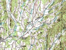
The USGS topographical map archive is the map database most familiar to most people. Outdoorsmen are used to purchasing these paper maps from their nearest camping supply store for a few dollars. Many are not aware, however, that this data is also available in raster format (digital raster graphic or DRG format, to use the jargon), making them the most familiar source of DEM information.
Raster USGS topo maps cover all of the United States. They were formerly available for free from a commercial web site gisdatadepot.com. Unfortunately, this site recently discontinued the free distribution of free DRGs. Those desiring free data must access the free state GIS websites. A listing of these sites can be found at www.nb.net. The data can also be downloaded from the archive site www.topowest.com. Free data is only available for about half of the US states.
Frequent users may wish to examine the topo map database included with DeLorme's TopoUSA. This program is descibed in the section entitled DEM Starter Kit. Alternatively, casual users may benefit from another commercial site called TopoZone. You have to pay for the maps here, but for quick reference or for screen-grabbing a small map section it is worth checking out.
Topo maps are interesting from several respects. They provide useful elevation data directly, and they can be overlaid on top of DEMs (see below). In fact USGS topos and the USGS numerical elevation database were prepared from the same source data, typically aerial stereo photography. Topographical maps have even been scanned and "reverse engineered" to extract DEM data for areas where numerical data is not readily available (see the section in the following pages.)
|